President Barack Obama will visit Guam sometime in March and the importance of his visit to the military build-up can’t be understated. But it’s really hard to know what to make of his visit or how it might affect the build-up.
Obama’s visit may be very short, and his exposure to the build-up may be entirely from the military's perspective. His trip may be little more than a briefing and a meeting with the troops before moving on. Some of this may depend on whether the White House wants to get the president involved in the build-up debate, particularly since the Pentagon seems to be set on it no matter what issues or concerns are raised.
But the president will be likely briefed about the build-up, and hopefully his briefing papers will include this column in the Marianas Variety by Brian Schaible, a marine biologist, who succinctly outlined some of the many problems the build-up will create for Guam.
If Obama stays more than a few hours and meets with local officials, then I hope that this meeting includes people who have expressed concerns so that the president gets a complete view of the build-up's impact.
The U.S. officials in charge of the build-up on Guam are middle managers. They have no power of consequence. Their mission is to minimize obstacles and concerns to the build-up. My expectation is that the U.S. will make a number of adjustments to the build-up plan in response to opponents, but these changes will be mostly cosmetic and malleable. The only person with power to change this is President Obama, so that’s why it will be important he gets a full range of views.

Wednesday, February 3, 2010

Wednesday, November 25, 2009
History of earthquakes on Guam
The U.S. Environmental Impact Statement (EIS), prepared for the military buildup, has some great summaries about Guam's environment. Most of this information reported is in the public domain and can be pieced together, but the EIS does a nice job of creating a narrative that gives some sense of the historical flow.
One source of information about Guam's earthquake history is the United States Geological Survey
Here's the EIS summary:
Guam experiences occasional earthquakes due to its location on the western edge of the Pacific Plate and near the Philippine Sea Plate. In recent years, earthquakes with epicenters near Guam have had magnitudes ranging from 5.0 to 8.7.
On October 30, 1936 (October 29, Universal Time), a magnitude 6.7 shock occurred about 80 mi (125 km) southwest of Guam. Walls were cracked and plaster and tile fell.T he seismic observer at Guam reported 25 tremors during the day of October 30. Another earthquake originated in the same area as the 1936 shock on September 16, 1970. The magnitude 6.2 tremor caused minor damage on Guam. A similar occurrence on November 1, 1975 (magnitude 6.2) produced damage on Guam that reached $1 million. The earthquake was felt strongly in many parts of the island.
On January 27, 1978, a magnitude 5.2 earthquake centered near the east coast of Guam caused considerable damage on the island. On August 8, 1993, the largest earthquake (magnitude 7.8) recorded on Guam occurred south of the Mariana Islands, injuring 48 people on Guam and causing extensive damage to hotels in the Tumon Bay area. Many landslides and rockslides were reported, mainly in the southern half of the island. The estimate of loss from damage to commercial buildings was placed at $112 million and loss from damage to private residences estimated at several million dollars.
One source of information about Guam's earthquake history is the United States Geological Survey
Here's the EIS summary:
Guam experiences occasional earthquakes due to its location on the western edge of the Pacific Plate and near the Philippine Sea Plate. In recent years, earthquakes with epicenters near Guam have had magnitudes ranging from 5.0 to 8.7.
On October 30, 1936 (October 29, Universal Time), a magnitude 6.7 shock occurred about 80 mi (125 km) southwest of Guam. Walls were cracked and plaster and tile fell.T he seismic observer at Guam reported 25 tremors during the day of October 30. Another earthquake originated in the same area as the 1936 shock on September 16, 1970. The magnitude 6.2 tremor caused minor damage on Guam. A similar occurrence on November 1, 1975 (magnitude 6.2) produced damage on Guam that reached $1 million. The earthquake was felt strongly in many parts of the island.
On January 27, 1978, a magnitude 5.2 earthquake centered near the east coast of Guam caused considerable damage on the island. On August 8, 1993, the largest earthquake (magnitude 7.8) recorded on Guam occurred south of the Mariana Islands, injuring 48 people on Guam and causing extensive damage to hotels in the Tumon Bay area. Many landslides and rockslides were reported, mainly in the southern half of the island. The estimate of loss from damage to commercial buildings was placed at $112 million and loss from damage to private residences estimated at several million dollars.
Sunday, November 1, 2009
The PDN's Liberation Day propaganda
I never much cared for Guam's Liberation Day celebration and in writing this I don't mean to marginalize the heroic sacrifice of U.S. troops in freeing the island from Japanese occupation. But the celebration always struck me as a bit much, considering Guam's history as a trophy possession by major powers. There are events of equal consequence to the people of this island, if not even more, that are given little attention. Most notably, is the turning over of Guam by Spain to the U.S. as part of the 1898 Spanish-American War settlement.
An interesting paper published in the Journal of Communication Inquiry looks at the role of the of the Pacific Daily News for this historical blindness. The author, Francis Dailisay of Washington State University, traveled to Guam to examine the newspaper archives and conclude that the newspaper is essentially a vehicle for reinforcing the American occupation and expansion.
Dailisay's analysis is a worthwhile read. For instance, even in those cases were the newspaper reported opposition to America's occupation ...
One conclusion is that the PDN has downplayed this conflict to foster U.S. control of the island.
It's important to note that this paper's analysis concerns coverage over many years. Newspapers are fluid, living things and the philosophies and approaches of the current staff may not necessarily reflect historical patterns. Newspaper reporters, in my experience, are often the last people around to blindly accept authority. But this research paper, nonetheless, offers a means to assess the PDN's coverage. The work isn't available online and has to be purchased. Here's a link. It ought to be required reading in any newsroom considering anew: what does it mean to serve readers?
An interesting paper published in the Journal of Communication Inquiry looks at the role of the of the Pacific Daily News for this historical blindness. The author, Francis Dailisay of Washington State University, traveled to Guam to examine the newspaper archives and conclude that the newspaper is essentially a vehicle for reinforcing the American occupation and expansion.
Dailisay's analysis is a worthwhile read. For instance, even in those cases were the newspaper reported opposition to America's occupation ...
...the PDN found it necessary to reaffirm the actors’ loyalty to the United States. This was a strategy used by the newspaper to legitimize local dissenting opinions that challenged dominant American ideologies. These findings reveal how a local, mainstream newspaper in a U.S. colonial context presents the resistances of colonized actors within a socially controlled manner.
One conclusion is that the PDN has downplayed this conflict to foster U.S. control of the island.
Because the PDN was part of an American corporation (Gannett) at the time of this study, it may have chosen to do this in order to secure the continued flow of U.S. capital to Guam, which the PDN needed to support its daily news operations.
It's important to note that this paper's analysis concerns coverage over many years. Newspapers are fluid, living things and the philosophies and approaches of the current staff may not necessarily reflect historical patterns. Newspaper reporters, in my experience, are often the last people around to blindly accept authority. But this research paper, nonetheless, offers a means to assess the PDN's coverage. The work isn't available online and has to be purchased. Here's a link. It ought to be required reading in any newsroom considering anew: what does it mean to serve readers?
Saturday, September 12, 2009
Guam as the modern day Bikini Atoll
Guam and the Bikini Atoll share an awful lot, with one exception. The U.S. used this Marshall Islands atoll for nuclear testing, vaporizing part of it and irradiating whatever was left and then leaving it uninhabitable. The U.S. committed a great wrong on Bikini and to its people but what happened to Bikini is very relevant to what the U.S. is doing to Guam today. It is far more relevant and timely than you may realize.
In October – this October, 2009 -- the “People of Bikini” asked the U.S. Supreme Court to hear its case for reparations. The U.S. is fighting them. If the Supreme Court agrees to hear this case, the travesty of U.S. colonial actions on Bikini and in the Pacific will get a national stage. And anyone who wants to see whether the U.S. has really changed how it treats Pacific islanders only has to look to Guam to find out that it hasn't changed at all.
The first similarity is this: There is nothing that Guam can do about the U.S. military build-up other than trying to mitigate the impact, which is exactly the position the Bikini islander’s faced. Its 167 inhabitants “believed themselves powerless to resist the United States decision,” according to the 2006 lawsuit by the Bikini people that is now the underpinning of the recent Supreme Court filing. [The case history is on BikiniAtoll.com]
Guam has no choice in the build-up. The interests of the people of Guam are secondary to U.S. strategic needs. The people of Bikini lost their entire island. Guam’s people have lost about 27% of their island to the military and stand to lose more. Disfranchised from voting and out of mind in Washington, Guam has no more voice in the build-up than the Bikini islanders did.
The second similarity is this: The Draft Environment Impact Statement (DEIS) wasn’t written to protect Guam. It was written to protect the U.S. government from criticism once things go wrong on Guam. Bikini’s history illustrates how this will happen.
Bikini’s islanders were relocated to Rongerik, an uninhabited and unlivable atoll. It was made up of a ring of 17 small islands totaling .65 square miles, with a lagoon that covered about 55 square miles. Bikini, in contrast, had 23 islands covering 3.4 square miles and a nearly 300 square mile lagoon.
The planning for Bikini had failed. Rongerik was inadequate to meet the needs of the Bikini people. “The islanders soon discovered that the coconut trees and other local food crops produced very few fruits when compared to the yield of the trees on Bikini,” wrote Jack Niedenthal, a historian and author about the island, and Trust Liaison for the People of Bikini Atoll. The islanders were soon starving.
Instead of acknowledging this mistake, the government shifted its responsibility. In a 1947 press statement, U.S. officials wrote:
“… the natives selected Rongerik themselves. We built them houses, schools and watersheds on that island and they were perfectly happy initially. Later it developed that the island was not as productive as originally expected and we had to augment their food supply by bringing in food for them. Last summer they had a disastrous fire on the island which destroyed about one third of their palm trees.” [New York Times, Oct. 26, 1947.]The U.S. will respond in similar fashion to any problems caused by Guam’s build-up, just as they did in 1947 when they wrote that, “the natives selected Rongerik themselves.” That was not the truth. The natives never wanted to leave.
The U.S. will say that the 11,000 page DEIS is evidence of its great concern and care for Guam. It’s just the opposite. It’s a pile of data and observation dumped on the island far too late, and Guam has been given precious little time – just 90 days – to respond to it. The buildup, as the DEIS illustrates, impacts every aspect of the island; the environment, land use and development, schools, health care, crime, roads -- the sum of Guam’s quality of life. With the DEIS in hand, Guam’s government must now prioritize the buildup’s impact and then prepare mitigation strategies. It’s a Manhattan Project-sized task and one that’s impossible to complete in the amount of time available. Guam can rest assured that the U.S. will use the DEIS as its defense when things go wrong: We prepared you, Guam.
But the DEIS doesn’t begin to anticipate what may happen as a result of the build-up. And what happened on Rongerik provides an example. The fire that destroyed one third of the island’s palm trees was an unintended and unanticipated consequence of the relocation. Guam will see similar occurrences. There are always unintended consequences, and Rongerik also illustrates what will happen afterward.
After it became clear that Rongerik could not support Bikini’s population, the U.S. searched for a different island to again move the Bikini islanders. Here’s some more from the press statement to the New York Times: (Note: King Judah, referenced below, was the Bikini leader.)
“… we have been trying since April to find a place for them to live and we took [King] Judah and a number of the leading natives to various islands for them to look over. We could not get them, however, to make a decision as to where they wanted to go. They continued to make the statement that they wanted to go back to Bikini.”From the U.S. perspective, the problem was that the “leading natives” of Bikini could not make a decision. That’s the story that the U.S. wanted to world to know. The perspective of the people on Bikini was certainly different. They had been uprooted from their homes, and evidently believed that returning – at some point – was possible. (Where did they get that idea?) The islanders could see the repeated flashes of nuclear explosions destroying their homes, and their new home, Rongerik, had proved disastrous. They wanted to return to Bikini and couldn’t. Did the Bikini people have any reason left to trust the U.S.? Did anyone hear their side of the story?
Here’s the third and last similarity I want to draw. A 1947 column by a newspaper reporter, Harold Ickes, carried a report on the starvation underway on Rongerik that was read in Washington. “We Fought the Navy and Won,” a book about Guam under U.S. Navy rule by Doloris Cogan, includes an account of what happened.
Ickes had detailed information about the lack of food and agonizing conditions on Rongerik. When the report came out, a U.S. Navy official responded in a Washington newspaper, where Ickes column evidently appeared, and said the charges were untrue. But, perhaps unknown to the letter writer, the Navy had just released a report by Dr. Howard MacMillan, an agricultural specialist working for a company that delivered food, “and it corroborated all of Ickes’ statements,” wrote Cogan.
Ickes' column helped to bring attention to the terrible conditions facing the Bikini islanders, as well as expose the military’s immediate denial as a falsehood.
Guam, of course, isn't facing starvation, but instead will have to deal with the impacts of a massive population increase in the limited environment.
Today, Guam’s population is 178,400 (CIA Factbook July 2009) and in the buildup’s peak year of 2014 it will be at 257,600 – a 44% increase, a figure that does not appear to include underlying population gains (15% since 2000). Also not included in this estimate are the occasional surges of several thousand people when aircraft carrier crews arrive. Once the build-up is completed and the military presence is stabilized, it will add 33,431 people, an 18% increase alone from 2009, to the island.
I tend to think these population estimates are conservative and don’t really account for the response to reports of Guam’s “boomtown” atmosphere, or decisions by foreign workers not to leave.
To ensure that the concerns on Guam get fair hearing, I suspect that Guam will have to develop strategy to counter the government’s official positions but they will have do this from Washington. There is no doubt many national nonprofit groups, environmental organizations for instance, that could help Guam, if this help is sought.
Guam residents have a compelling story to tell and a means to fight Washington, but they may be no better off than the people of Bikini if the world doesn't know just what is really happening.
Sunday, August 9, 2009
One-in-four jobs on Guam are government jobs
Unemployment on Guam* always seems to be around 8% and above even in good times, but the island's employment has been relatively stable in this downturn.
Private sector employment fell from 45,580 to 44,910 from June 2008 to June 2009 a net decline of 670 jobs or 1.5%, according the Guam Labor Dept.’s most recent employment report.
Guam's total employment, which is the sum of the public and private sector labor force, is 59,340, a decline of 590 from a year ago or a 1% decrease. Not bad for a recession.
A major reason for this relative stability (no real job growth or decline) is the high percentage of people who work for Guam's government or as a federal civilian.
The government of Guam, which includes utilities, employed 10,640 in June, a reduction of 80 jobs over 12 months. The federal government employed 3,790 people in June, an increase of 160 jobs from a year ago. In total, about one in four people on Guam works for the government.
Regarding population:
2000: 155,000
2008: 171,000
Excepted population after military build-up: 196,000
*Unemployment data for Guam, at least for me, seems difficult to come by. If anyone knows a source that reports quarter-by-quarter trends, please let me know.
Private sector employment fell from 45,580 to 44,910 from June 2008 to June 2009 a net decline of 670 jobs or 1.5%, according the Guam Labor Dept.’s most recent employment report.
Guam's total employment, which is the sum of the public and private sector labor force, is 59,340, a decline of 590 from a year ago or a 1% decrease. Not bad for a recession.
A major reason for this relative stability (no real job growth or decline) is the high percentage of people who work for Guam's government or as a federal civilian.
The government of Guam, which includes utilities, employed 10,640 in June, a reduction of 80 jobs over 12 months. The federal government employed 3,790 people in June, an increase of 160 jobs from a year ago. In total, about one in four people on Guam works for the government.
Regarding population:
2000: 155,000
2008: 171,000
Excepted population after military build-up: 196,000
*Unemployment data for Guam, at least for me, seems difficult to come by. If anyone knows a source that reports quarter-by-quarter trends, please let me know.
Wednesday, August 5, 2009
Guam Weather, Typhoon Season, and 236 mph wind gust

One of the strongest storms to ever hit Guam was Super Typhoon Paka on December, 1997. It struck with sustained winds that may have reached 185 mph with a gust recorded at Andersen Air Force Base (in the north near the storm eye) that reached an astonishing 236 miles per hour. It was as if the island had been hit by a giant tornado.
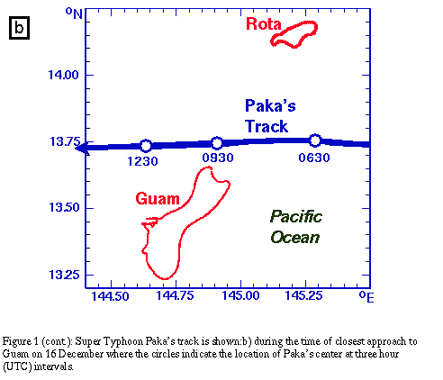

By contrast, Hurricane Camille, which hit the Gulf Coast in 1969, had sustained winds of 190 mph, with estimated gusts near 200 mph. Hurricane Allen in 1980, which struck Northern Mexico and Southern Texas also had sustained winds of 190 mph.
The threat from super typhoons is the reason most structures on the island are made of concrete; often low rising buildings with flat roofs. The damage caused by Paka was extensive, especially to wood structures. Guam residents know how to cope with these storms but Paka was a test.
It's been pretty quiet so far this year. Wikipedia does an outstanding job keeping record of the major tropical events this season. The latest weather event is Tropical Storm Morakot. which is nearly a 1,000 miles NW of Guam as a write this. The weather has been unstable and rainy on Guam, pictured above, the result of Morakot, which is outside this photo in the upper left.
Saturday, August 1, 2009
Jobs on Guam
I was checking USAJobs.gov to see how many federal jobs are available on Guam and, surprisingly, there were over 3,000 results after typing in the word “Guam” as a location. But refining the search to “Guam” as the keyword, and "Agana" as the city with a search radius of 60 miles (covering the entire island), produced a different result: 36 Guam specific jobs.
Among the federal jobs: Mandarin teacher with U.S. DOD, office automation clerk, electronics engineer, and fire protection, among others.
Monster.com turned up 13 results, but six were Army National Guard enlistment teasers.
Some other sources: Pacific Daily News listed about 35 jobs, many in the travel related area.
Interesting find on PDN: The American Red Cross is looking for an emergency services director.
University of Guam always has a fair number of jobs.
Great link collection to various government sites here
Guam Department of Labor has resources and links.
Among the federal jobs: Mandarin teacher with U.S. DOD, office automation clerk, electronics engineer, and fire protection, among others.
Monster.com turned up 13 results, but six were Army National Guard enlistment teasers.
Some other sources: Pacific Daily News listed about 35 jobs, many in the travel related area.
Interesting find on PDN: The American Red Cross is looking for an emergency services director.
University of Guam always has a fair number of jobs.
Great link collection to various government sites here
Guam Department of Labor has resources and links.
Subscribe to:
Posts (Atom)